Information for Fire Response Protocol
Dave Gratton, New Zealand Tree Grower February 2008.
Fire danger is always a worry for forest owners during summer months. You can always minimise the possibility of a fire outbreak by using commonsense actions during those hot months, but sometimes a fire can start by any number of ways without you being anywhere around.
The big problem rural fire fighters have is not knowing who the forest owners are and how to contact them, as well as where the forest roads are to get to a fire quickly.
The Fire Response Protocol will give that information to your Principal Rural Fire Officer.
Example:
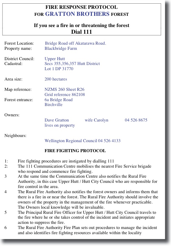 Every district and city council should have a Rural Fire Officer who is involved only in fire activities within the rural sector in their area. They have knowledge and training in fighting vegetation fires rather than the city fire officers who are trained in fighting fires in structures. In many cases the Principal Rural Fire Officer is also the council emergency manager.
If a fire can be controlled quickly before it becomes a mayor blaze then life, property, and your forest may be saved. In many instances it may take up to an hour to reach a rural fire by vehicle, if they know where the roads or tracks are. You will need to keep in mind the protocol may be used for helicopter fire fighting, so the information needs to list the hazards to a helicopter, such as power lines, and if available water points for refilling monsoon buckets.
Protocol information
There are two protocols listed, one already filled out as a sample and one blank for you to insert your own details. Map reference in this instance use the old style map reference sheets, and is where your road access point is located. Remember this information is not only needed for ground based vehicles to arrive quickly but also for identification in the air by helicopter. Make sure your road access identification or rapid number is clearly seen on your letterbox or gate access using either map reference or GPS reading.
Maps from Google
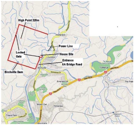 Aerial maps will need to be made by you, and should show if possible, potential water locations, hazards for aerial fire fighting as well as locked gates and roading. The sample map illustrated was obtained by going to our local council web site.
In the council map section we clicked on Google maps, typed in our location address including New Zealand and clicked on search.
If your computer skills are like mine and limited, just print the map and draw on the printed version the boundaries and other details you need. Boundary lines and more visible roads will be shown already but in a lighter shade. However there are large numbers of computer savvy people around that can easily draw on screen those and other details, and print the completed map in a professional manner. This is only one way to generate a map, and there are other organisations that can supply what you need but there are generally costs attached.
Once the protocol is filled out and the aerial map printed on the reverse side, so all the information is on one A4 sheet, then take it to your Principal Rural Fire Officer. This can then be held on file for when it may be needed. It is also very helpful to give a copy of the map to your neighbours so they know the procedure to follow if a fire in your forest should start. In many instances they are the first ones to call 111.
For more information visit the National Rural Fire Authority.