Pigeon Valley fire - New methods put to the test
Grant Pearce and Harriet Palmer, New Zealand Tree Grower August 2019.
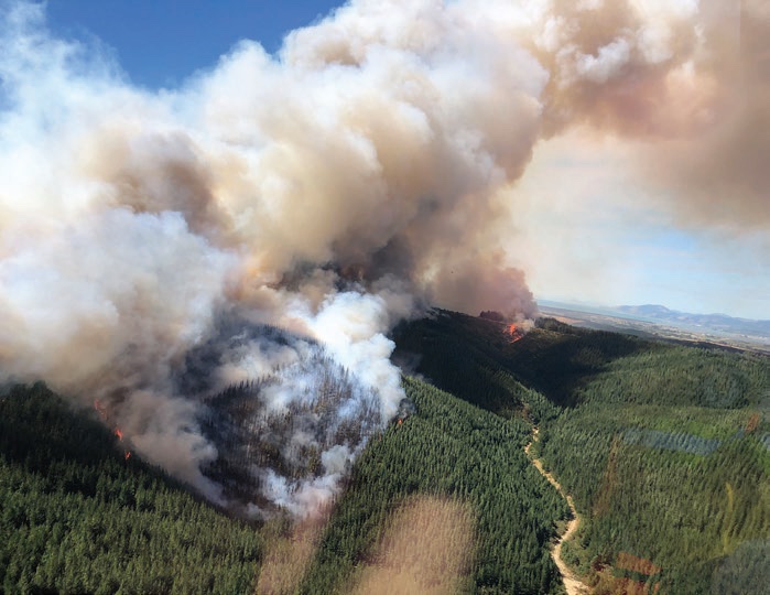
The February Pigeon Valley fire near Nelson was New Zealand’s largest forest fire in more than 60 years. The fire burned over 2,300 hectares and caused the evacuation of more than 3,000 people and 700 livestock. The Scion Rural Fire Research Group, part-funded by the Forest Growers Levy, put their research into action to provide on-the-ground assistance with incident management.
The Christchurch-based Scion Rural Fire team has over 20 years of experience in fire research. The team is currently halfway through a five-year ‘Extreme fire’ research programme to increase understanding of extreme fire, and develop new ways to predict, prevent and fight such fires. The project is funded by the Forest Growers levy and the Ministry of Business, Innovation and Employment. A big element of the research effort has been working with international fire-research scientists, especially from the United States, to develop a set of integrated decision-support methods to help emergency services in all aspects of fire prevention and control.
Extreme fire
The Pigeon Valley fire was almost all within a mixed- ownership forestry plantation. The area included a range of different ages of plantation trees, from recent cut- overs and re-planting to intermediate and mature stands. The area had been in a drought and high fuel loads were available for the fire after it started. The weather was warm, dry and windy, the land was steep, and the fire spread very rapidly following ignition.
The fire showed ‘extreme fire’ behaviour, burning with high intensity, producing flames up to 30 metres high, and throwing embers 500 metres or more ahead of the spreading flame front. At these levels of intensity, the fire was unstoppable using any of the fire-fighting methods available, so the fire-fighting strategy was a defensive one, evacuating people, protecting properties, and attempting to limit the spread of the fire around its boundaries.
Incident management teams
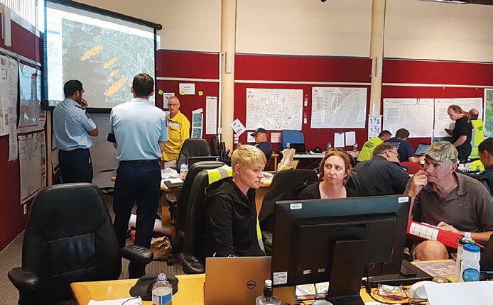
Scion’s fire scientists are regularly called upon to join the incident management teams when serious rural fires break out in New Zealand. Researchers have been part of the incident management team in several recent major fires, including the 2017 Port Hills fire and the 2015 Marlborough forest fires. During the Pigeon Valley fire, fire scientist Veronica Clifford was embedded in the Fire and Emergency New Zealand incident management team.Veronica spent the best part of two weeks using methods developed by Scion and collaborators to help support fire operations.
Two of the more sophisticated methods under development are a fire growth prediction model called Prometheus, and smoke modelling originally developed by the US Forest Service called BlueSky framework. During the Pigeon Valley fires, Veronica was running the Prometheus model together with data obtained from drones on infra-red hotspot detection to predict the potential for fire flare-ups and escapes. This information was critical to decisions on evacuation and road closures, and the process for re-entry of evacuated properties. The Scion team also ran the BlueSky model frequently to produce smoke predictions which were used by fire, civil defence and public health agencies to inform the public of potential health concerns.
Being part of the operational team during fires provides the best possible opportunity for Scion’s fire research team to test their models under real conditions. They also collect data to validate and improve models. Back at base, the team has the ability to reconstruct fires after the event, which enables them to gain a better understanding of what happened and why.
Developing methods for operational fire-fighting
As part of the Ministry of Business, Innovation and Employment extreme fire programme, Scion is linking fire detection, fire growth prediction and smoke methods with high-resolution weather forecast data for near real-time prediction of fire spread and effects. The aim is to develop integrated methods to a point where they become part of the regular methods used by emergency services in fire-fighting. By 2020, Scion hopes to have a prototype ready to trial with Fire and Emergency New Zealand. They aim to run the models as part of their day-to-day operations, giving them better, faster, information on fire occurrence, spread and potential effects.
The research team is confident the time is not too far away that, when a new fire starts anywhere in the country, it will be automatically detected using thermal infrared satellites. Information on fire starts will link into the latest weather data, collected from a number of sources, and then feed into the fire behaviour prediction model, Prometheus. This will be run to provide an indication of where the fire is likely to go and how fast it will spread. Fire-fighting resources can then be mobilised much more rapidly and effectively than in the past.
Using smoke
The BlueSky model will predict how much smoke will be generated, how dense it will be and how the smoke will move. It will provide early warning of any potential hazardous situations caused by smoke – for example, around residential areas, roads and airports. Colour- coded videos of smoke movement can be distributed via the internet showing likely hazard levels. The smoke model has already been used by Fire and Emergency New Zealand and other emergency services during hazardous waste fires. It is likely to be made available to Civil Defence and public health agencies to help guide decisions around evacuations and health warnings when fires break out and where the smoke may affect residential and urban areas.
As time goes on it is anticipated that there will be much greater automation of many fire detection and control operations. Drones are already used for operations such as hot-spot sensing, and the use of drone-based technology is considered to have a big potential in future fire-fighting work. For example, drones can provide improved fire situational awareness information, and fleets of drones could even be used to carry water to extinguish fire in areas that cannot be reached by other means.
Climate change and forest fire risk
Inevitably, many parts of the county will see greater increases in fire danger with climate change. Research indicates that areas that would not currently be perceived as having high fire risk may see quite dramatic increases in the future including, such as coastal Otago, Manawatu, and around Wellington and Whanganui. Areas that already have severe fire risk − Marlborough, Canterbury and the North Island’s East Coast − are expected to see slight increases over current levels.
As well as more severe fire weather days with climate change, fire seasons are also expected to get longer, starting earlier and extending later in many areas. Warm wet winters may, surprisingly, add to the fire risk. The rain and warmer conditions increase vegetation growth, which then dries out causing higher fuel loading. More dry fuel means greater risk of fires, higher fire intensity and more difficulty in controlling fires when they do break out.
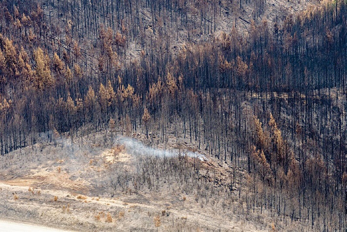
Depending on species, silvicultural treatments, age and how many rotations there have been, different forest stands accumulate higher fuel loads on the ground. An important factor in the fire spread and intensity of the Pigeon Valley fire was the fact that there was a lot of fuel on the ground, which among other things resulted in a prolonged mop-up period to extinguish deeper burning fires. Fires can burn up to around two metres deep in the right conditions, making then almost impossible to extinguish without physically digging out and damping down the smouldering material.
Fire risk management plans
For all forest owners, the winter months provide an opportunity to look at fire risk management plans and review against current best practice. Questions small forest owners may wish to consider include −
- Do you have a fire plan and is it lodged with your local Fire and Emergency New Zealand?
- Do you have adequate insurance?
- Do you have any first-response firefighting resources such as fire extinguishers and shovels to deal with small fires before they get out of hand?
- Do you require and check that contractors working in your forests have fire-fighting equipment?
- Do you have sufficient water sources and do you know where the nearest water sources are?
Fire breaks
Forest owners, including those planting new forests, may also wish to consider the size, location and management of fire breaks within the forest. Owners of small forests are unlikely to find it practical to have many fire breaks, but even having one or two well-located breaks, and managing tracks or other access routes as fire breaks, may contribute to fire safety.
On steep land, fire breaks are best located in the bottom of gullies or on the tops of ridges, as these are where fire spread will be slowest and the break has the best chance of being effective. In gentler land, a network of well-spaced linked fire breaks works best. These can take advantage of compartment boundaries between stands of different ages that will burn with different fire behaviour. As a rough rule of thumb, a fire break needs to be two to three times as wide as the height of the vegetation. Remember that planted trees will get taller as they get older, or up to twice as wide as the flame lengths produced by a fire.
Slowing fire speed
In younger forests where there is more chance of fires burning at a lower intensity, fire breaks will slow the speed of spread, provide access for fire-fighting and escape routes for forestry workers and fire fighters. In older forests, and if a high-intensity or extreme fire develops, flames can be tens of metres high, and even without embers being transferred, fire breaks would need to be 40 to 60 metres wide to slow the fire’s spread.
However, narrower breaks can still be useful, particularly in stopping the spread of lower intensity flank and back fires, which can reduce the overall area burned significantly. Spot fires which breach a break also take time to develop in speed and intensity. The presence of a second fire break in close proximity to another break, within around 200 to 500 metres, can aid greatly in containing these spot fire break-outs. Some of the recommendations for managing fire breaks include −
- Pruning outside rows of trees
- Planting lower flammability shrub species around the edges of the firebreak
- Regular maintenance by reducing the build-up of dry flammable material such as grasses. Grazing livestock may be one practical option when trees are large enough to be resistant to browsing.
More information for forest growers
New fire management guidelines funded by the Forest Growers Levy are currently being developed including some specifically for small forest growers. A National Rural Fire Authority booklet Fire Management Guidelines for Small Forests may still be available. In addition, there is some good information on the Fire and Emergency New Zealand website.
Scion’s Rural Fire Research Group is working on behalf of all New Zealand’s forest growers on a variety of projects to improve rural fire prevention, management and safety − website www.ruralfireresearch.co.nz.
Grant Pearce is Senior Fire Scientist, Scion. Harriet Palmer is an independent forestry communications specialist.